
2025 Summer Guide
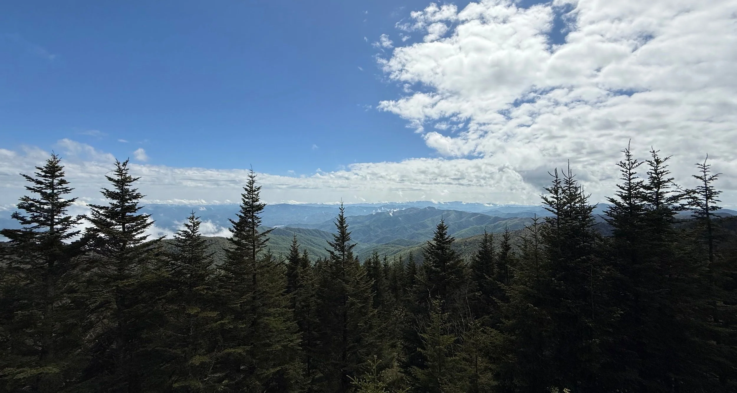
View from the Kuwohi parking area in Great Smoky Mountains National Park
As the communities of Western North Carolina recover from Hurricane Helene, it can be hard to know what’s open at a time when these areas need support from both locals and tourists. I’ve built this summer guide to navigate those difficulties— it is by no means an exhaustive list, but it serves as a jumping off point for further exploration. As an artist, hiker, and a Madison County business owner, most of my recommendations focus on these areas of expertise.
Support the Arts
These mountains have a rich history of craft heritage, so its no wonder the arts scene is a big draw for locals and tourists alike. Here are a few spots where you can support local artists.
Recovering Galleries in Madison County
Flow Gallery in hard-hit Marshall, NC was one of the first businesses to reopen in the quaint river + railroad town. The gallery features work from artists in a variety of mediums from across Western North Carolina.
Artisan Gallery + Cafe in riverside Hot Springs, NC has just begun work on their flood-ravaged building, but they have temporary set up a beautiful gallery at 311 NW US 25 70 Hwy. Supporting the gallery at the new location supports their artist community and their rebuild effort.
The Folk Art Center
The Folk Art Center is headquarters for the Southern Highland Craft Guild and houses a huge shop featuring the work of regional artists, as well as three galleries on the upper level. The Folk Art Center is located on the Blue Ridge Parkway and while much of the Parkway remains closed, you can access the Folk Art Center! The National Parks Service also has a small shop + info center at the Folk Art Center, so you can get all your Parkway questions answered as well.
Please note: Due to Parkway closures, GPS has been struggling with navigation to the Folk Art Center and often sends folks to the service entrance. If your navigation tells you to turn left on Riceville Road— don’t! Continue straight on Tunnel Road— in less than a mile (from the light at Riceville Road), there will be a Blue Ridge Parkway sign and entrance on your right. Follow the signs onto the Parkway, and follow the signs to the Folk Art Center. Easy peasy!
River Arts District
The River Arts District (RAD) in Asheville was home to over 700 artists before the storm and many are still displaced. While the “Lower RAD” along the river is being rebuild and reevaluated, the “Upper RAD” was large spared and needs your support more than ever. While particular artist/studio hours vary, the following buildings are open to the public— take a peek inside and see what you find!
Pink Dog Creative - home to 35 working artist studios
Aura Arts - home to Trackside Studios, Jaime Byrd Contemporary Art Gallery, and Clayworks
Wedge Studios - home to 30 working artist studios
You can also support the RAD, including many displaced artists, at their temporary downtown Asheville RADA Outpost (24 N Lexington Ave) and the RAD Art Market happening every Saturday 10-5pm at 130 Roberts St.
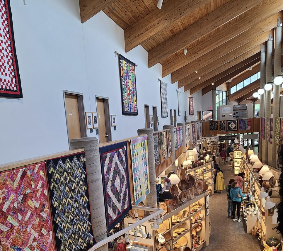
Folk Art Center

River Arts District
Raise a Glass
Asheville and the surrounding area is known for it’s craft beer industry. Beer plays a huge part in the local economy and the continued support of this industry helps us keep a network of job opportunities for our local population. Here are a few hard-hit breweries that can use your help.
Mad Co Brew House in Marshall, NC was completely submerged in floodwaters, but they have fully reopened, including their pizza kitchen! Don’t miss the back patio, which is right on the river.
Mars Theater Brewing Company— While the town of Mars Hill was largely spared, the family behind this establishment also owned a brewery in Chimney Rock that was completely lost in the storm. Support these fine folks as they pivot all their energy and efforts into their Mars Hill location. Bonus: The brewery is inside an old theater, so you may catch some live music or a classic movie if you go on the right day!
Hi-Wire in the River Arts District (RAD) - Hi-Wire, one of the founders of the Asheville beer scene, had their RAD location (and company headquarters) completely submerged in floodwaters. They are proudly the first business to reopen in the “Lower RAD”. Hungry while you’re there? They plan to always have a food truck on site, or you can pop down the street to Baby Bull and get one of the best burgers in town.

Bailey Mountain
Take a Hike
Finding open and accessible hiking trails can be a tough business these days, but there are a ton of options thanks to the hard work of volunteers and the Forest + Park staffs.
A few notes:
Many popular areas, particular those along the Blue Ridge Parkway, as still closed due to landslides and other hazards. If you come to an area that says it’s closed, it’s CLOSED. This is for your safety and the safety of park and forest staff. If that’s not enough of a deterrent, I’ve heard rumors of fines as high as $5,000 for folks entering closed areas.
All Trails is a great resource for finding trails and navigating to trailheads. Many trails will have closure information right at the top. A good rule of thumb is to look at the reviews— is there a review since September 2024? If not, that trail is probably closed. Recent reviews will also often have information about trail conditions, including if there are downed trees, cleared trees, or other storm-related issues.
Recommended Trails
The Laurel River Trail is a popular hiking and swimming spot between Marshall and Hot Springs. As far as trails go around here, this trail is FLAT and great for almost all fitness levels. I’ve talked to many locals who just assume that this trail is closed since it follows a river, but it miraculously looks untouched by storm damage. The trail is about 4 miles long, so you can hike up to 8 miles round trip. If you do make it all four miles to the trail’s end, the Laurel River flows into the French Broad River, which is an eerie sight to behold these days. Please use caution if you explore this area, as the French Broad was not so lucky at the Laurel River.
The Bailey Mountain Preserve in Mars Hill doesn’t offer five star views or a waterfall, but it’s easily accessible, beautiful forest, and sustained minimal damage. This was the only trail myself and many other locals knew was open soon after the storm— many thanks to the folks that made that possible! This trail is a moderate hike— you’ll definitely get your heart rate up. If you want a shorter hike with a nice reward, there’s a sweet little overlook about 1/3 of a mile in.
It’s hard to pick one trail in Brevard, so let’s talk about a few! This area was largely spared during Helene— one local even told me they thought Helene’s floodwaters removed some of the “tree trash” left in the the Davidson River by Tropical Storm Fred in 2021. Some trails in the area are closed, so always check before you go. There is also a Visitors Center on 276 (1600 Pisgah Hwy, Pisgah Forest, NC 28768) that can help you navigate the area. Please note that there is usually not cell service in this area, so know your plans in advance!
Family-Friendly Waterfalls - Looking Glass Falls is a favorite and it’s right on the side of the road! There is a handicap-accessible viewing platform as well as a combination of ramps and stairs to get to the base of the falls. You can even swim here, but the water is COLD year-round. If you go by Looking Glass and want to get a short hike in too, head a little further down 276 to Moore Cove Falls. This 1.2 mile roundtrip hike leads you to one of the few waterfalls you can walk behind.
Looking for more of a challenge with a big payoff? The famous Looking Glass Rock Trail is also in this area— this ~6 mile roundtrip route is challenging but offers spectacular views.
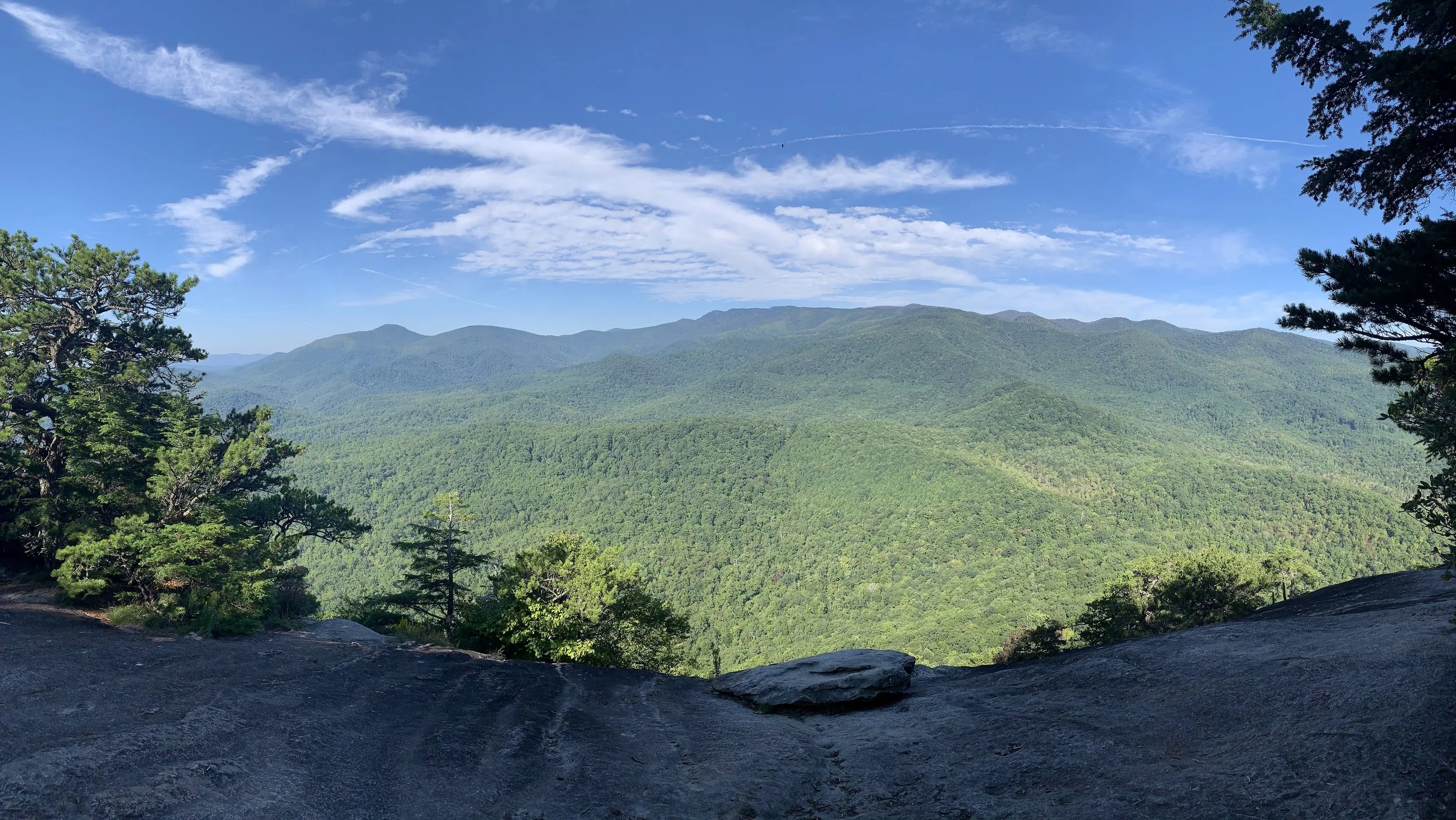
View from Looking Glass Rock
Soak Up the View
While much of the Parkway is closed, a gorgeous section around Pisgah Inn is open, as well as the inn itself! Make a reservation to enjoy a delicious meal at the inn’s restaurant— one whole wall of the dining room gives you windows full of those beautiful Blue Ridges. After your meal, head south on the parkway to stop at a few overlooks. Bonus: you can see Looking Glass Rock from many of these overlooks, so if you plant to hike it, it’s fun to get this perspective as well!
Max Patch - This famous spot on the Appalachian Trail is well-known for a reason. If you catch it on a clear day, you’ll be rewarded with 360 degree views. Accessing this spot includes driving on a dirt road for several miles, and then a half mile hike to the clearing.
Sad about missing the Blue Ridge Parkway? Driving along 441 through the Great Smoky Mountains National Park offers spectacular views as well! There are lots of pullouts along the way, and make sure you drive up to Kuwohi (formerly Clingman’s Dome). The observation tower offers the best views, but you’ll have to hoof it up a steep paved path to get there. Not feeling it? The views from the parking area are spectacular as well!
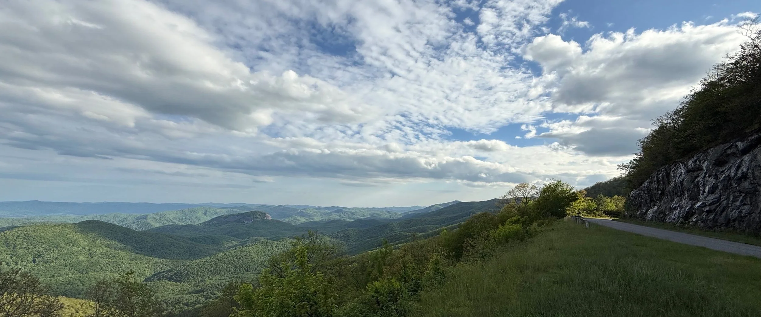
View of Looking Glass Rock from the Blue Ridge Parkway